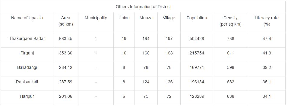
Literacy: The Literacy Rate of Thakurgaon
district is 48.70% (Male- 53.00% and Female- 44.40%), school attendance rate is
56.70% for 5 to 24 years age group.:

About Thakur
Gaon village
Thakur Gaon
is a village located in Sahar Block of Auraiya district in Uttar Pradesh.
Placed in rural area of Auraiya district of Uttar Pradesh, it is one of the 95
villages of Sahar Block of Auraiya district. As per the administration records,
the village code of Thakur Gaon is 148378. The village has 254 houses.
Population
of Thakur Gaon village
Thakur
Gaon's population is 1583. Out of this, 844 are males while the females count
739 here. This village has 256 kids in the age group of 0-6 years. Among them
129 are boys and 127 are girls.
Literacy
rate of Thakur Gaon village
Literacy
ratio in Thakur Gaon village is 64%. 1024 out of total 1583 population is
literate here. Among males the literacy rate is 70% as 597 males out of total
844 are literate whereas female literacy rate is 57% as 427 out of total 739
females are literate in
this Village.
The Negative part is that illiteracy rate of Thakur Gaon village is 35%. Here 559 out of total 1583 persons are illiterate. Male illiteracy ratio here is 29% as 247 males out of total 844 are uneducated. In females the illiteracy ratio is 42% and 312 out of total 739 females are illiterate in this village.
The Negative part is that illiteracy rate of Thakur Gaon village is 35%. Here 559 out of total 1583 persons are illiterate. Male illiteracy ratio here is 29% as 247 males out of total 844 are uneducated. In females the illiteracy ratio is 42% and 312 out of total 739 females are illiterate in this village.
Agricultural
status of Thakur Gaon village
The count of
working person of Thakur Gaon village is 564 however 1019 are non-working. And
out of 564 employed individual 337 peoples are fully dependent on cultivation.