Showing posts with label Economy. Show all posts

Sunday, April 3, 2016

Economy Thakurgaon District

History
During British rule Thakurgaon was a tehsil (a district subdivision). In 1947 at the time of the Partition of India, Thakurgaon Subdivision became part of East Pakistan and became part of the newly established Dinajpur District of East Bengal. In 1984 Takurgaon subdivision was split off Dinajpur and became a separate district (i.e. Thakurgaon District).


Economy
In Bangladesh as a whole agriculture is the basis of the economy, and Thakurgaon has been striving for a long time to be economically productive, agriculture forming a major part of the districts economy. Thakurgaon produces many agricultural products, such as rice, wheat, sugarcane, seasonal vegetables and fruits etc. The sugarcane plantation - TSM (Thakurgaon Sugar Mill)--is part of the BSFIC. These become the main livelihood of the native. Poultry firms are quite productive business in Thakurgaon, there are several cold-stores in the district. Different businesses for producing and repairing agricultural tools have grown up.

However the community's distance from the capital causes difficulties in getting sufficient technical and logistic support and in transporting local products to the national market. It is not easy for the investors to set up their business far away from the center of national trade and commerce.

Friday, April 1, 2016

Population Census Information Of Thakurgaon District

Thakurgaon District (rangpur division) area 1809.52 sq km, located in between 25°40' and 26°12' north latitudes and in between 88°05' and 88°39' east longitudes. It is bounded by panchagarh district on the north, Panchagarh and dinajpur districts on the east, west bengal state of India on the south and west.
Population Total 1214376; male 627200, female 587176; Muslim 924254, Hindu 278703, Buddhist 7156, Christian 131 and others 4132. Indigenous communities such as santaloraonmunda, Mushar and rajbangshi belong to this upazila.
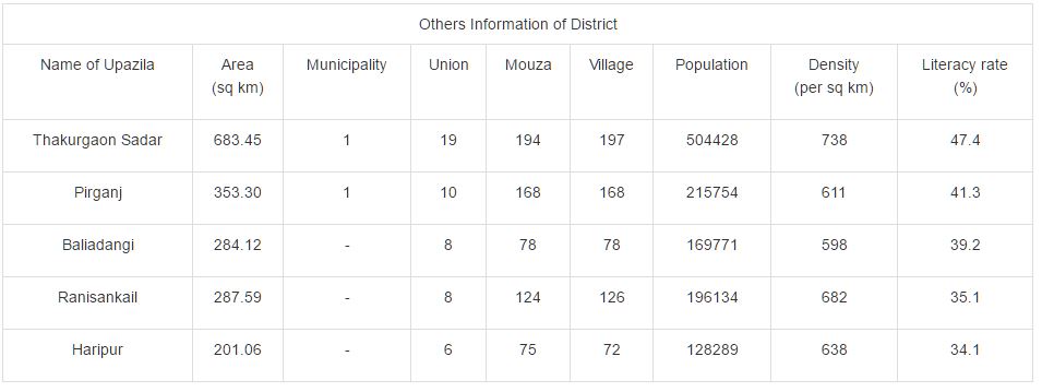
Administration Thakurgaon Sub-division was established in 1860 under the district of Dinajpur and was turned into a district in 1984. Of the five upazilas of the district thakurgaon sadar was the largest (683.45 sq km) and haripur is the smallest (201.06 sq km).

Thursday, March 31, 2016

Location Of Haripur Upazila In Thakurgaon District

Haripur (Bengaliহরিপুর) is an Upazila of Thakurgaon District in the Division of Rangpur,
 Bangladesh.As of the 1991 Bangladesh census, Haripur has a population of 101658. Males constitute 50.93% of the population, and females 49.07%. This Upazila's eighteen up population is 49922. Haripur has an average literacy rate of 19.5% (7+ years), and the national average of 32.4% literate.

Pirganj Upazila Of Thakurgaon District Information

Pirganj (Bengaliপীরগঞ্জ (ঠাকুরগাঁও)) is an Upazila of Thakurgaon District in the Division of RangpurBangladesh.As of the 1991 Bangladesh census, Pirganj has a population of 183292. Males constitute 51.69% of the population, and females 48.31%. This Upazila's eighteen up population is 92296. Pirganj has an average literacy rate of 29.3% (7+ years), and the national average of 32.4% literate.

Details Information Of Thakurgaon Sadar Upazila

Thakurgaon Sadar (Bengaliঠাকুরগাঁও সদর) is an Upazila of Thakurgaon District in the Division of RangpurBangladesh.Thakurgaon Sadar is located at 26.0208°N 88.4667°E . It has 79823 households and total area 683.45 km².