Showing posts with label Haripur. Show all posts

Sunday, April 3, 2016

Haripur Upazila

Haripur Upazila
Haripur (Bengaliহরিপুর) is an Upazila of Thakurgaon District in the Division of RangpurBangladesh

Geography
Haripur is located at 25.8083°N 88.1417°E . It has 19559 households and total area 201.06 km².
Demographics
As of the 1991 Bangladesh census, Haripur has a population of 101658. Males constitute 50.93% of the population, and females 49.07%. This Upazila's eighteen up population is 49922. Haripur has an average literacy rate of 19.5% (7+ years), and the national average of 32.4% literate.[2]
Haripur has 6 Unions/Wards, 75 Mauzas/Mahallas, and 70 villages.

Gallery Haripur


See also

Friday, April 1, 2016

Population Census Information Of Thakurgaon District

Thakurgaon District (rangpur division) area 1809.52 sq km, located in between 25°40' and 26°12' north latitudes and in between 88°05' and 88°39' east longitudes. It is bounded by panchagarh district on the north, Panchagarh and dinajpur districts on the east, west bengal state of India on the south and west.
Population Total 1214376; male 627200, female 587176; Muslim 924254, Hindu 278703, Buddhist 7156, Christian 131 and others 4132. Indigenous communities such as santaloraonmunda, Mushar and rajbangshi belong to this upazila.
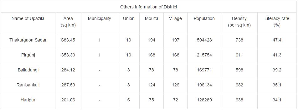
Administration Thakurgaon Sub-division was established in 1860 under the district of Dinajpur and was turned into a district in 1984. Of the five upazilas of the district thakurgaon sadar was the largest (683.45 sq km) and haripur is the smallest (201.06 sq km).

Thakurgaon District Information

Profile
Thakurgaon subdivision was established in 1860 and was turned into a district in 1984. The district consists of 2 municipalities, 18 wards, 32 mahallas, 5 upazilas, 51 union parishads, 643 mouzas and 643 villages.
Upazilla/ Thana
Baliadangi Upazila, Haripur Upazila, Pirganj Upazila, Ranisankail Upazila, Thakurgaon Sadar Upazila
Bounded by
Panchagarh district on the north, west bengal of India on the west and south, Panchagarh and Dinajpur districts on the east.


Thursday, March 31, 2016

Location Of Haripur Upazila In Thakurgaon District

Haripur (Bengaliহরিপুর) is an Upazila of Thakurgaon District in the Division of Rangpur,
 Bangladesh.As of the 1991 Bangladesh census, Haripur has a population of 101658. Males constitute 50.93% of the population, and females 49.07%. This Upazila's eighteen up population is 49922. Haripur has an average literacy rate of 19.5% (7+ years), and the national average of 32.4% literate.