Thakurgaon District Bangladesh


Thakurgaon
district is located in the north- western borderline of Bangladesh. With the
initiative of a Tagore family, a police station was established nearby the
current Thakurgaon Municipality during the East India Company period. The
police station was named after them. Thakurgaon subdivision was established in
1860. At the time of Partition in 1947, three police station of Jalpaiguri
district and a police station of Kochbihar (current 4 police station of
Panchagarh except Atowary), Panchagrah started its new journey as a subdivision
with total ten police stations. In 1981, Panchagrah subdivision was separated
with Atowary, Panchagrah, Boda, Debiganj and Tetulia police station of
Thakurgaon sub division. As a result the geography of Thakurgaon was limited
with five police stations. Panchagrah sub division was turned into a district
on 01 February 1984 with current five police station. Previously it was
included with Dinajpur District.
Bordered By:
Thakurgaon District is bordered by Panchagarh district to the north, West Bengal (Indian
State) to the south and west, Dinajpur and a part of Panchagarh district to the
east.
Administration:
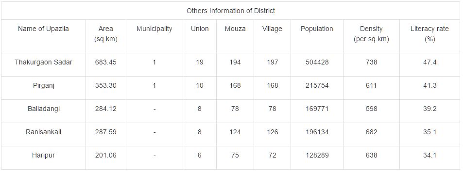
The area of Thakurgaon is 1781.74 Sq Km. It is under Rangpur Division. There
are 03 Municipalities in Thakurgaon named Thakurgaon, Pirgonj and Ranigonj. The
number of Upazilla (sub district) in Thakurgaon district is 05, named-
Thakurgaon Sadar, Ranishonkor, Baliadanga, Haripur and Pirgonj containing 51
Unions, 636 Mauzas and 641 Villages.
Population:
The total population of Thakurgaon district is 13,90,042 (Male- 701,281 and
Female- 688,761), Sex ratio 102:100, Population Density 780/Sq Km and annual
growth rate is 1.34%.
Literacy:
The Literacy Rate of Thakurgaon district is 48.70% (Male- 53.00% and Female-
44.40%), school attendance rate is 56.70% for 5 to 24 years age group.
Other
Important Data: The postal code of Thakurgaon district is 5100 and NWD Code is
0561. Total Parliament seat in Thakurgaon is 03. During the liberation war,
Thakurgaon was under Sector Number 07 and total listed freedom fighter is 1730.
Average rainfall of the district is 2536 mm and urbanization rate of the
district is 11.60%. Major Tribes living in the region are Munda, Bordo, Sawtal,
Oraw, Choch, Palia, Rajbangshi, Whoo, Kumar, Hari, Bhuyan, Ganghu etc.
Rivers: Tangon,
Kulic, Nagor, Tirnoi, Pathraj, Vulli, Dipa, Julai, Churamati etc.
Agro
Products: Paddy, Jute, Wheat, Sugarcane, Tobacco, Pulses, Potato, Brinjal,
Vegetables, Mango, Jack fruit, Papaya, Watermelon, Litchi etc.
Remarkable
Personalities from Thakurgaon District
Subeder
Ahmed Hossain (Freemon Fighter), Mohammad Dabirul Islam (Politician), Shishir
Battacharja, Principal Ashraful Alam Khan, Abul Kalam Azad, Mirza Ruhul Amin
(Politician), Alhaz Nurul Hoque Chowdhury (Politician), Hazi Kamrul Huda
Chowdhury (Social Worker), Khorshed Ali Ahmed (Social Worker), Mohammad Fazlul
Karim (Politician), Mohammad Rezawanul Hoque Chowdhury (Politician), Sayad
Jahanara (Social Worker), Engineer Ejab Uddin Ahmed (Social Worker), Dr Abdul
Malek, Prof. Golam Mostafa etc.

Tourist
Places in Thakurgaon District
Thaguregaon
Sugar Mill, Ranishagor Lake, Ranishankar Royal Palace, Haripur Royal Palace,
Pirgonj Fun City, Senua Bridge, Gorakkhya Nath Temple and adjecent Kupa and
Inscription, Haripur Royal Palace, Bolaka Park, Core of Ancient Building,
Jagadal Royal Palace, Thakurgaon Power Plant, Tongnath Royal Palace, Old Air
Port (Destroyed during the Second World War), Jomidar Mosjid at Shibganj,
Jamalpur Jame Mosque, Surjapuri Ancient Mango Tree at Baliadangi, Ramrai Lake,
Khunia Lake, Gorkoi Heritage, The river of Kulic, Khunia Dhighi Memorial,
Harinmari Shibmondir, Gobinda Nagor Temple, Koram Khan Garh, Tangon Dam, Shapla
Peala Lake, Bangla Garh, Malduar Royal Palace etc.